Action needed · Tuesday, April 28, 2026
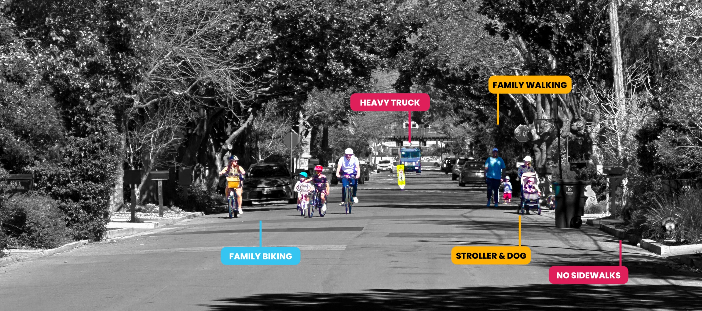
College Avenue is a designated bicycle boulevard and a daily walking and biking route to Middle Plaza, Stanford Medical, the San Mateo Drive bridge, and Downtown/Little House/Nealon Park. There are no sidewalks across most of the corridor. People are forced into the travel lane every day. The Slow Streets Program does not need to be perfect to deliver real safety here. We need Council to approve the program tonight with binding directives to staff to fix the program-wide gaps, and to launch a 90-day quick-build pilot on College Avenue. Then measure the result and scale citywide.
This is not a new or unfair ask. In the Menlo Park General Plan Circulation Element, College Avenue is an official bicycle boulevard. And yet despite years of resident requests, the City has never acknowledged the designation in practice or applied any treatment on the basis of the classification. College Ave measurably fails the NACTO performance standards a bicycle boulevard is supposed to meet.
We are asking the City to deliver on its duty of care — and waiting for years of planning does not work.
College Avenue connects Middle Plaza, Stanford Medical, the San Mateo Drive pedestrian-and-bike bridge, and Nealon Park/Little House/Downtown. Sidewalk gaps run across the majority of the corridor. Children walking to school, families on bikes, runners, and seniors share the travel lane with through-cut traffic. This is a daily, unavoidable, unsafe exposure documented in the City's own files and in ground-truth sensor data. See the data →
The intervention on Middle Avenue (speed humps and posted-limit reduction) shifted some traffic onto parallel residential streets. College Ave absorbs that spillover. Ground-truth sensor data show a residential street carrying meaningful through-cut volume at speeds that exceed 25 mph and that climb sharply in the tail.
The Slow Streets Program scores eligibility largely by 85th-percentile vehicle speed. By definition, that excludes the fastest 15% of drivers. Those are the drivers most likely to cause a severe-injury or fatal collision, especially on a street where people are already in the lane.
In the best case, 85th-percentile speed is not an ideal measure for the goals of a residential traffic safety program. In our case it is worse, because the data source the program is built on is demonstrably inaccurate for Menlo Park neighborhood streets compared to ground-truth measurements — including the City's own official ground-truth measurement.
A simple, defensible directive Council can attach to tonight's approval, fitted inside the proposed framework:
Pedestrian-in-Roadway Exposure factor. Award qualifying points when sidewalk gaps force pedestrians and cyclists into the travel lane across a meaningful share of the corridor (for example, ≥50% of segment length). Apply additional weight when the corridor connects activity generators such as schools, parks, transit, medical campuses, and pedestrian-and-bike bridges.
Exposure override. Where exposure is high, qualify the corridor for pilot eligibility regardless of the 85th-percentile speed score. The point of the program is to address risk, not to confirm where collisions have already happened.
This is short enough to read into the record as a binding directive and durable enough to apply citywide. Staff can incorporate it without another year of drafting.
This is not a new or untested scheme. We are asking Council to apply on College Avenue exactly the toolkit that SFMTA deployed on Sanchez Street and that Caltrans (in its 2023 Safe System case-studies report, Case Study #12) holds up as a model. Sanchez has held a 50%+ vehicle reduction and a 36% collision reduction for five-plus years on a comparable residential bike corridor — same designation, same scale, same scope of intervention.
College has the conditions of a clean test case for the same approach: documented exposure, a defined corridor, an active resident community, the Sanchez peer reference, and a sensor already collecting data. Use it.
Why 90 days. Long enough to capture a meaningful before-and-after dataset. Short enough that mid-course adjustments are cheap. At the end of the pilot, Council has hard numbers — speeds, volumes, pedestrian counts, emergency response times — and a clear basis to decide whether to scale, adjust, or stop.
Why College. The need is documented. The advocacy is already organized. The peer reference (Sanchez Street) has held a 50%+ vehicle reduction for five years on a comparable corridor. Side-by-side comparison →
First, the data is not accurate. Second, the risk on College is exposure plus tail-speed, not only v85 speed. The 85th percentile excludes the drivers who set fatality severity by definition. Adopt a max or 95th-percentile readout in the pilot data, or apply the exposure override.
College is already a de facto shared street because there are no sidewalks. The pilot designs for the existing condition; it does not invent a new one. Caltrans (2023 case-study report) holds up San Francisco Slow Streets as a model of the same approach.
The pilot uses soft measures only: signs, flexible delineators, paint, visual narrowing. No closures, no vertical deflection. Coordinate with Fire on the design and monitor response times during the pilot. If response times move, adjust the design. The pilot is reversible by definition.
The amendment is a citywide criteria change: any street with significant sidewalk gaps qualifies for pilot eligibility. College is simply the first because the conditions are documented and the advocacy is ready. Other neighborhoods follow the same path, on the same criteria.
This is not a fight against the Slow Streets Program. It is the constructive path that makes the program work for the streets where the need is highest. Council does not need to rewrite the framework from the dais — just approve it tonight with binding directives to staff to incorporate the fixes. The City is not freed from doing this work by another revision cycle. Delay is the most expensive option on the table: another year, another set of crashes, and the same conditions on the same streets.
Pick the angle that matches your concern. Add your name and neighborhood. Hit send. Council clerks log every email in the meeting record, so your message lands on every Councilmember's desk before they vote.
Sources cited.